


Le Ray Twp. Voting District, Blue Earth County, Minnesota
About
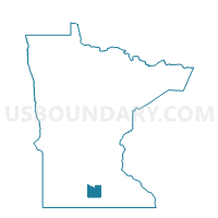
Outline

Summary
| Unique Area Identifier | 601250 |
| Name | Le Ray Twp. Voting District |
| County | Blue Earth County |
| State | Minnesota |
| Area (square miles) | 34.82 |
| Land Area (square miles) | 32.20 |
| Water Area (square miles) | 2.62 |
| % of Land Area | 92.49 |
| % of Water Area | 7.51 |
| Latitude of the Internal Point | 44.15039940 |
| Longtitude of the Internal Point | -93.82191970 |
Maps


Graphs
Select a template below for downloading or customizing gragh for Le Ray Twp. Voting District, Blue Earth County, Minnesota


Neighbors
Neighoring Voting District (by Name) Neighboring Voting District on the Map
- Alton Twp. Voting District, Waseca County, MN
- Decoria Twp. Voting District, Blue Earth County, MN
- Eagle Lake Voting District, Blue Earth County, MN
- Elysian Twp. P-2, Le Sueur County, MN
- Jamestown Twp. Voting District, Blue Earth County, MN
- Janesville Twp. Voting District, Waseca County, MN
- Lime Twp. Voting District, Blue Earth County, MN
- Madison Lake Voting District, Blue Earth County, MN
- Mankato Twp. Voting District, Blue Earth County, MN
- McPherson Twp. Voting District, Blue Earth County, MN
Top 10 Neighboring County Subdivision (by Population) Neighboring County Subdivision on the Map
- Eagle Lake city, Blue Earth County, MN (2,422)
- Mankato township, Blue Earth County, MN (1,969)
- Lime township, Blue Earth County, MN (1,395)
- Decoria township, Blue Earth County, MN (1,104)
- Elysian township, Le Sueur County, MN (1,046)
- Madison Lake city, Blue Earth County, MN (1,017)
- Le Ray township, Blue Earth County, MN (746)
- Jamestown township, Blue Earth County, MN (693)
- Janesville township, Waseca County, MN (513)
- McPherson township, Blue Earth County, MN (466)
Top 10 Neighboring Place (by Population) Neighboring Place on the Map
Top 10 Neighboring Unified School District (by Population) Neighboring Unified School District on the Map
- Mankato Public School District, MN (63,382)
- Waterville-Elysian-Morristown School District, MN (6,685)
- Janesville-Waldorf-Pemberton Public School District, MN (4,857)
- St. Clair Public School District, MN (2,631)
Top 10 Neighboring State Legislative District Lower Chamber (by Population) Neighboring State Legislative District Lower Chamber on the Map
- State House District 23B, MN (43,520)
- State House District 25A, MN (40,391)
- State House District 24B, MN (36,327)
Top 10 Neighboring State Legislative District Upper Chamber (by Population) Neighboring State Legislative District Upper Chamber on the Map
- State Senate District 25, MN (85,965)
- State Senate District 23, MN (82,921)
- State Senate District 24, MN (71,152)
Top 10 Neighboring 111th Congressional District (by Population) Neighboring 111th Congressional District on the Map
Top 10 Neighboring Census Tract (by Population) Neighboring Census Tract on the Map
- Census Tract 1702, Blue Earth County, MN (5,176)
- Census Tract 1701, Blue Earth County, MN (4,635)
- Census Tract 9504, Le Sueur County, MN (3,838)
- Census Tract 1713, Blue Earth County, MN (3,822)
- Census Tract 7901, Waseca County, MN (3,364)
- Census Tract 7903, Waseca County, MN (3,137)